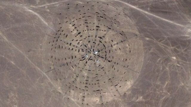
Strange images have been found on Google Maps of the Gobi desert. Conspiracy theorists have many ideas on what it could be such as a secret military base.
Discover our latest podcast
The images show that there are some peculiar grids and patterns in the Gobi desert:

In the image, there are a bunch of strange structures organised into a circle, not unlike the Stonehenge. Youtube channel 'thirdphaseofthemoon's' creators believe that this could be evidence of a'UFO runway' or even 'an area 51 for China'. It's surely not far off the mark, I mean there are 3 planes parked in amongst the structures.
However, commenters had other ideas, some claimed that 'maybe it's a huge solar panel for underground living,' or the abandoned 'City 404.'
One person was very confident in their response, blaming the Youtube channel for creating suspense over nothing:
Stop with the hype, it’s a test rang for reconnaissance aircraft, their cameras and targeting equipment. Every country that puts satellites up has ballistic missiles or a fleet of ISR aircraft has a range like this.
However, now that Google Maps have updated, viewers have a different picture of the coordinates given by 'thirdphaseofthemoon', 43°04'51.75"N/92°48'26.85"E.

The area where the Gobi's Stonehenge should be has been replaced with another strange pattern. Unfortunately, Google Maps disabled users from zooming in to see any details of the image, but this isn't the first time these types of patterns have appeared in the area.
Many other fascinating 'crop circle' type structures have been popping up in the Gobi Desert for years:


Internet users have been overlaying the patterns onto U.S. city maps to see if they reveal any malicious intent. But, others have been smart to point out that if China wanted to attack the US. they wouldn't need a desert target to practise.
One expert claims that all of these patterns are in fact, something else altogether. Expert Johnathan Hill, a research technician and mission planner for the Mars Space Flight Facility at Arizona State University, claims that the grid-like structures are actually spy satellite calibration targets. The targets help the satellites to orient themselves in space.
Hill told Life's Little Mysteries that these grids aren't actually all that rare and many countries (including the U.S) use them:
"An example I found just now is a calibration target for the Corona spy satellites, built back in the 1960s, down in Casa Grande, Ariz., [at coordinates] 32° 48' 24.74" N, 111° 43' 21.30" W,"
In regards to the Stonehenge-like feature, it seems like Hill has an explanation for that too:
"This is almost certainly a calibration/test target for orbital radar instruments. Since a significant amount of radar return is due to differences in surface roughness, they're probably testing ways of making the areas around planes 'bumpy' enough that the planes are partially masked."
Hill did notice something else though, that all of these structures, including some extras such as a weapons testing zone, seem to be rather close together:
"I think we're seeing some sort of military zone/test range, which explains the large amount of equipment and technology in an otherwise remote area, Sometimes the truth can be just as interesting, if not more so, than the conspiracies that people come up with."
So maybe it isn't China's Area 51 but it sure must hide some military secrets.


